

Tourist Place of Bandarban
Bandarban:


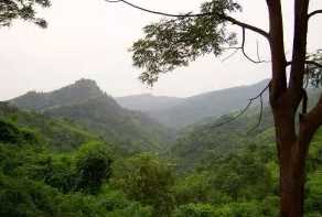
Bandarban, the newest tourist destination of Bangladesh. Previously, for lacking of some privilege for the visitors.But Bangladesh government has taken some useful decision and presented it as a beautiful tourist place for the visitors also. It is also a hilly district like Rangamati in the country.There are more beautiful tourist spot in Bandarban like Boga Lake,Buddha Dhatu Jadi,Chimbuk Hill and Tribal Villages,Keokradong,Meghla Tourist Spot,Nilachal Tourist Spot,Mirinja Parjatan,Nafakhum and Remakri,Nilgiri and Thanchi,Prantik Lake,Rijuk Waterfall,Sangu River,Shoilo Propat,Tajingdong,Upabon Parjatan.
Boga Lake:


Boga Lake is the most beautiful natural lake in Bangladesh. It is also known as Bagakain Lake or Baga Lake. Boga lake is 18 kilometer away from Ruma Sadar Upozilla in Bandarban. The area of this lake is about 15 acres. It is about 3000 feet above sea level. The color of water of this lake is blue and very nice. There are many mythological stories behind the creation of this lake. There are many tourists make their way to Boga lake every year, specially in the winter season. Small tribe community like Bawm, Khumi have localities besides the Boga lake. In the rainy season, it is quite difficult to stroll beside the boga lake. The road from Ruma to Boga lake is still under construction. There waiting lots of pleasure and delight for you at Boga lake. You will definitely be amazed looking at the big rocks lying in and out of the Boga lake. You can have a camp fire beside the lake, that will be unbelievable and mind-blowing memory in your life.
Buddha Dhatu Jadi:


The Buddha Dhatu Jadi is a Theravada Buddhist temple also known as the Bandarban Golden Temple. The Buddha Dhatu Jadi is located at Pulpara 4 kilometer from Balaghata town and 10 kilometer from in the remote Bandarban hill district, in Bangladesh. The Bandarban Golden Temple is the largest Theravada Buddhist Temple with the second largest Buddha statue in Bangladesh.
The Buddhist temple is known in local language as kyang. The Buddha Dhatu Jadi is regarded as one of the holy site for Theravada Buddhism followers and Buddhist pilgrims. This religion is practiced by the Marma or Mogh tribal group of the Chittagong Hill Tracts, a dominant ethnic group in Bandarban. They are of Arakan descent and Buddhists by religion.
Chimbuk Hill:


Chimbuk hill is the third highest mountain in Bangladesh. Chimbuk is one of the most familiar tourist spot in Bandarban. It is just 26 kilometer away from Bandarban sadar. Chimbuk hill is about 2500 feet high above sea level. The road of this area is zigzag. So if you ride in a jeep it will be charming. While your jeep is moving through the various indigenous villages, their simplicity in human gestures will compel you to think about our predecessors struggles to cope with to maintain existence. They are as simple as nature. However when you are looking down from Chimbuk, it will get you the feelings of floating over the clouds. When it is a shiny day, you can see the shades of clouds over the hills. The huge horizon of zigzag hills seem waves of a see. You will also see the beauty of Chimbuk and Nilgiri.
Meghla Tourist Spot:


Meghla Parjatan Complex is the most amazing tourist or visited spot for the tourists coming from all over the country. Meghla is in the contiguous area of the Bandarban hill district council on the gateway of Bandarban maintained by district administration. It is 4 km from the town on the road to Keranihat, which features a mini-safari-park, a zoo, boat journey, a hanging bridge and at the bottom of the hills artificial lake has been made. It is a popular place for picnic party. A lot of tourist makes the way to Meghla for celebrating their vacations.
There is another beautiful place to see near Meghla is called Nilachal also maintained by district administration. it is known as tiger hill. The view of Nilachal is so spectacular for snapping. Nilachal is the nearest tourist spot from Bandarban. It is situated at Tigerpara. It is near about 2000 feet above of sea level and 5 kilometer away from the Bandarban town. From here visitor can see the total glance of Bandarban town and a vast landscape. In the rainy season visitor can be thrilled walking through the clouds. Visitor can watch a golden twilight in the evening and also enjoy an evergreen moonlight in the moonlit night. During the winter season, it is awesome at the foggy morning. On the way to Nilachal, visitor can see some tribe villages with their raw natural expression.
Keokradong:
Keokradong is the second highest mountain of Bangladesh. Keokradong is about 4,035 ft (1,230 meters) high from the sea level. It is situated in 30km away from the Ruma sadar upazilla of Bandarban in Bangladesh. This remote area is full of natural beauty. Here you can see many small and big mountains and hills. This area is covered with dense forests, birds and animals.
Keokradong Mountain is located on the border between Bangladesh and Myanmar. It is the place of surprising beauty. This natural beauty is surely attracts the mind of the adventurous people. In the winter season many adventurous tourist visit this place with great excitement. You will pleased with the dazzling beauty of green hill, cool fountains, zigzag path, hilly road side, hide and seek game of clouds on the top of the hill.
Tajingdong:


Tajingdong also known as “Bijoy” is the highest mountain of Bangladesh. Tajingdong is about 4300 ft (1310 meters) high from the sea level. It is situated in remakri pangsha union under Ruma upazilla of Bandarban in Bangladesh. According to local tribal language “Tajing” means “Great” & “Dong” means “Hill” so that means “Great hill”.
There are various tribal community is developed surrounding the mountain and their living styles are so natural. This remote area is full of natural beauty. Here you can see many small and big mountains and hills. This area is covered with dense forests, birds and animals.
There are many tourist visits the Tajingdong Mountain in every year. It is the place of surprising beauty. This natural beauty is surely attracts the mind of the adventurous people. In the winter season many adventurous tourist visit this place with great excitement. You will pleased with the dazzling beauty of green hill, cool fountains, zigzag path, hilly road side, hide and seek game of clouds on the top of the hill.
Mirinja Parjatan:


Mirinja tourist spot (Parjatan complex) is situated at Lama upazilla of Bandarban district in Bangladesh. It is wonderful tourist spot in Lama. It is about 1500 feet high from sea level. In good weather, you can view Maheskhali Island, Bay of Bengal, Matamuhuri River and Lama upazilla at a glance. Parjatan Corporation developed an attractive tourist spot in that area. There is an observation tower in this spot.
Nilgiri and Thanchi:


Nilgiri or Nil Giri is one of the tallest peaks and beautiful tourist spot in Bangladesh. It is about 3500 feet high and situated at Thanci Thana. It is about 46 km south of Bandarban on the Bandarban-Chimbuk-Thanchi road. Beside this spot you can see Mro villages. Their colorful culture and living style are surely an unexplored experience for the visitors. In rainy season here creates a spectacular scenery, the whole spot is covered with the blanket of clouds. You can enjoy a cloudy experience. Winter is waiting for you with it’s foggy gesture on the height. It is a nice place for campfire in that season. Most attractive time is the dawn. It is better if you chose to stay during 7-18 dates of a lunar month to enjoy the moonlit night. You can also enjoy the serpentine course of Sangu River. This is the most spectacular tourist spot in Bandarban and managed by Army brigade of Bandarban.
Prantik Lake:


Prantik Lake is really beautiful tourist spot in Bandarban district of Bangladesh. This lake is surrounded by many kind of plants and trees. This amazing place will certainly attract tourist mind. Prantik Lake is an ideal place for travel.
Sangu River:


Sangu River is the complete part of the natural beauty of Bandarban. It follows a northerly circuitous course in the hill tracts up to Bandarban. It enters the district from the east and flows west across the district and finally falls into the bay of Bengal at the end of a course of 270 km. This river is flowing through the hills thousands of years. It is an important route to communicate with Ruma and Thanci Upozilla. It has huge financial interests for the population of Bandarban. This river is widely used for transportation, agricultural and other necessary products for the people of remote community.
Upabon Parjatan:Upabon Parjatan is another beautiful tourist spot in Bandarban at Naikhongchari. It is wonderful gift of nature. Here is an amazing lake surrounded by forest.
A lot of birds are singing here and you will surely be amazed looking at the big rocks and surrounding natural scene. There is a hanging bridge over the lake and it is longer than the Meghla hanging bridge. The view of Upobon is so spectacular for snapping.
Tourist place of Rangamati
Rangamati:


This 335feet long bridge across a portion of the Kaptai lake is an icon of Rangamati.

Rangamati is a small town located amongst the green hills, lakes and rivers of the Chittagong Hill Tracts.It is known as the Lake City of Bangladesh as this place is situated on the bank of the beautiful Kaptai Lake.It is situated at 77 kilometres away from Chittagong and it is the administrative headquarter of the Rangamati Hill District and the largest district of Bangladesh.There are many tourist place in Rangmati.
Kaptai Lake:

Shuvolong Falls:

Shuvolong Waterfalls is a good-looking waterfall in Rangamati. It is the attractive place of Rangamati.This place area 25 km away from Rangamati. The only obtainable path to influence at the waterfall is through water, through the lake. People visit there by boat. .There are few waterfalls in Shuvolong zone with the largest one falling from as high as 300 feet.Shuvolong is simply easy to get to by rapidity boat or motor boats from Rangamati.
Tribal Museum:

It`s located in Rangamati District.The Tribal Cultural Museum in the Hill Tracts of Bangladesh offers fascinating insight into the history and cultural traditions, as well as socio-economic aspects of the different tribes in the area. Visitors can view displays of tribal dress, ornaments, musical instruments, coins and handicrafts at the museu
Shajek and Marissa Vally:

Sajek is a union at Baghaichari Upazila in Rangamati districts. It is one of the big union in Rangamati districts. Basically it is name of a river which separates Bangladesh from India. The river flows into the Karnafuli River in the Chittagong Hill Tracts. Sajek Valley is situated in the North angle of Rangamati, near the Mizoram border boundary area. The valley is 18000 ft high form sea lavel. Many small rivers flow through the hills among them Kachalon and Machalong are famous. It is one of the biggest union in Bangladesh. Marishsha is a name of a place near Sajek Valley. Most of the houses are made by bamboo.Most attractions of the spot are sun set, rain, morning, evening, and night and aborigine people. Tourist can buy aborigine people product from indigenous Haat. Roads are like big snake spirals mountains. Most of the people are Buddhist and people are Christian here.
Hanging Bridge:

Kaptai lake is very beautiful blue watery lake was made by man in Rangmati.The size of Lake is more or less 11000 sq km.It is a huge lake and it has some tiny islands.Each island has different name such as “Peda Ting-Ting”, “Tuk-Tuk Echo Village”, “Chang-Pang” etc. “Peda Ting-Ting” .“Tuk-Tuk” is an echo park with varities of trees and plants. It is a great place for boating and cruising.
Hanging Bridge is 335 feet long bridge across a portion of the Kaptai lake is an icon of Rangamati. Actually Rangamati is famous for this bridge.It’s really a very beautiful bridge. Every year thousands of people come here to visit this bridge and lake.

Shuvolong Waterfalls is a good-looking waterfall in Rangamati. It is the attractive place of Rangamati.This place area 25 km away from Rangamati. The only obtainable path to influence at the waterfall is through water, through the lake. People visit there by boat. .There are few waterfalls in Shuvolong zone with the largest one falling from as high as 300 feet.Shuvolong is simply easy to get to by rapidity boat or motor boats from Rangamati.
Tribal Museum:

It`s located in Rangamati District.The Tribal Cultural Museum in the Hill Tracts of Bangladesh offers fascinating insight into the history and cultural traditions, as well as socio-economic aspects of the different tribes in the area. Visitors can view displays of tribal dress, ornaments, musical instruments, coins and handicrafts at the museu

Sajek is a union at Baghaichari Upazila in Rangamati districts. It is one of the big union in Rangamati districts. Basically it is name of a river which separates Bangladesh from India. The river flows into the Karnafuli River in the Chittagong Hill Tracts. Sajek Valley is situated in the North angle of Rangamati, near the Mizoram border boundary area. The valley is 18000 ft high form sea lavel. Many small rivers flow through the hills among them Kachalon and Machalong are famous. It is one of the biggest union in Bangladesh. Marishsha is a name of a place near Sajek Valley. Most of the houses are made by bamboo.Most attractions of the spot are sun set, rain, morning, evening, and night and aborigine people. Tourist can buy aborigine people product from indigenous Haat. Roads are like big snake spirals mountains. Most of the people are Buddhist and people are Christian here.
Hanging Bridge:

Kaptai National Park:


This forest reserve is located in the Karnafuly and Kaptai range. According to the government statistics some 50,000 people visits the national park every year
Cox`s Bazar
Cox's Bazar:

At present as the world's longest beach,Cox's Bazar has yet to become a beautiful tourist place in Asia.The area of Cox's Bazar 2491.86 square km.. It's is located at 21°35' N 92°01' E and is bounded by Chittagong District on the north, Bay of Bengal in the south, Bandarban District on the east, and the Bay of Bengal on the west.Main rivers are include Matamuhuri, Bakkhali, Reju Khal, Naf River, Maheshkhali channel and Kutubdia channel. The area of the city of Cox's Bazar is 6.85 square km is bounded by Bakkhali River on the north and East, Bay of Bengal in the West, and Jhilwanj Union in the south.
The beach is the main attraction of the town.There are many tourist attractions around Cox’s Bazar, which are easily accessible by Jeeps and in some cases cars.
1.Himchari:Himchari is a famous for Himchari Waterfall and natural beauty. It is situated about 8 km south of Cox’s Bazar. During the winter dry season, the waterfall dwindles but in the rainy season it is fabulous. Besides a beach drive to Himchari is an exotic experience.
2.Aggmeda Khyang: A large elaborately planned and decorated Buddhist Monastery. It is located near the entrance to the Cox's Bazar town. It has been designed to sit on a series of large timber columns. The monastery holds a big collection of manuscripts, prayer chamber, bronze Buddha images of Burmese origin and an assembly hall.
3.Ramu: Ramu is a typical Buddhist village.It is situated 16 kilometers away from Cox's Bazar. It is accessible from the main highway leading to Chittagong. The village accomodates monasteries, khyangs and pagodas. There are images of Buddha in gold, bronze and other metals inlaid with precious stones inside the pagodas. Temple on the Baghkhali River houses relics along with a 13 feet high bronze statue of Buddha rested on a six feet high pedestal. Wood carvings here is delicate and refined. In the village weavers ply their trade in open workshops and craftsmen make handmade cigars.
4.Teknaf:Teknaf is a small town which is situated at 80km from Cox’s Bazar is a memorable experience as the road goes alongside the beautiful Naf river and through forested hilly roads. Teknaf is the southernmost point of Bangladesh and is bordered by Myanmar.
5.Bangabandhu Sheikh Mujib Safari Park: Bangabandhu Sheikh MujibSafari Park is the first Safari Park in Bangladesh.It`s located along the Chittagong-Cox's Bazar road about 50 km from Cox's Bazar town.
6.Inani Beach:Inani is a stony beach near Cox's Bazar.


This place name is Saint Martin.It `s a very beautiful place in Bangladesh.It is a small island about 120 km far away from Cox’s Bazar district town in Bangladesh about this area 17 square kilometers.Only Water and water everywhere.It is a coral island in Bangladesh.The main agricultural products of this island are Coconut, onion, pepper, tomato and rice.Most of the people are involved in fishing profession.It`s a most attractive tourists place in Bangladesh for tourist.Thousands of people visits this place daily.
Subscribe to:
Posts (Atom)
Jaflong Is A Beautiful Tourist Place In Sylhet, Bangladesh
Jaflong of Sylhet is known as the daughter of nature. It is located in the foothills of Khasia Jainta hills, Juplong is a natur...

-
 Jaflong of Sylhet is known as the daughter of nature. It is located in the foothills of Khasia Jainta hills, Juplong is a natur...
 -
 Nilgiri Resort Bandarban Bangladesh Nilgiri Tourism Center is always a major tourist attraction because it is located at 2200 feet a...
 -
 Bandarban: Bandarban, the newest tourist destination of Bangladesh. Previously, for lacking of some privilege for the visitor...